Note
Need help? Please let us know in the UMEP Community.
3.4. Spatial Data: DSM Generator
Developer:
Name |
Institution |
|---|---|
Nils Wallenberg |
Gothenburg |
- Introduction:
Digital Surface Models (DSMs) is not always available for the area you want to investigate. The DSM Generator can be used to create or alter a DSM by using information from a polygon building footprint layer where a building height attribute is available. An option to acquire building footprints, and also in some cases building height from Open Street Map data, is available from this plugin.
- Dialog box
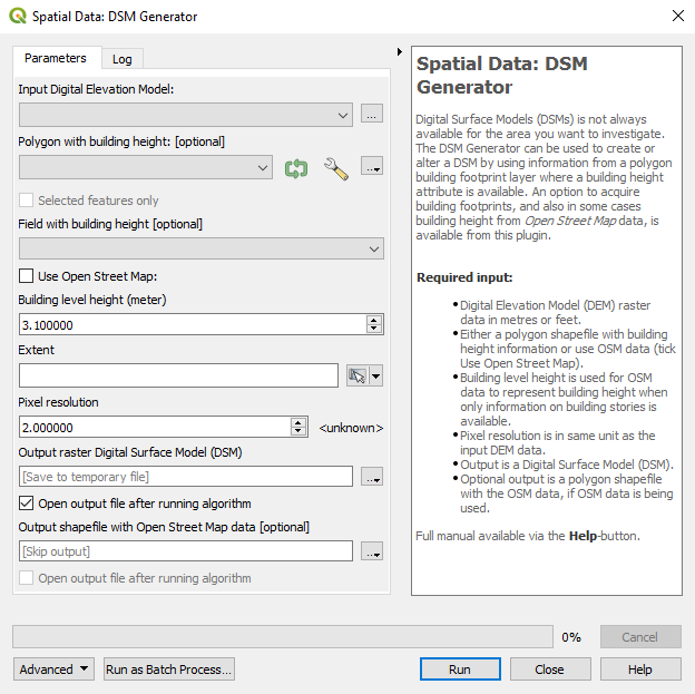
Fig. 3.5 Dialog for the DSM generator plugin
Dialog sections:
top |
input DEM data is specified |
middle upper |
input polygon with height data or OSM is specified |
middle |
map extent is specified |
middle lower |
to specify the output DSM and output resolution |
bottom |
to run the calculations |
- Digital Elevation Model:
A raster file containing elevation values needed to create the DSM. Raster elevation data (DEM) can be retrieved from e.g. OpenDEM.
- Polygon Vector File:
A polygon vector file including height values of buildings needed to create the DSM.
- Necessary attributes:
Building height values in meters.
- Use Open Street Map:
Tick this in if you do not have a polygon layer with building heights. Open Street Map (© OpenStreetMap contributors) data will be used instead. If no building height is found building level height will be used instead. Set to appropriate value, e.g. a three level building with building level height set to 3 will be 3 * 3 = 9 meters high.
- Save OSM as shapefile:
Tick this in if you want to save the Open Street Map data as a polygon layer. This can be used if you want to look at what values has been used and if you want to add values manually.
- Map extent:
Set either to map canvas extent or extent from layer. Extent have to be smaller or equal to the raster DEM extent specified in the top section.
- Digital Surface Model:
Set output for the generated DSM. Also set output resolution.
- Run:
Starts the calculations.
- Close:
Closes the plugin.
- Output:
One GeoTIFF is created, a DSM.
- Remarks:
The DEM raster and map canvas should be in a projection with meters as units.
Raster elevation data (DEM) can be retrieved from e.g. OpenDEM.
If you use Open Street Map make sure you read Open Street Map © OpenStreetMap contributors.