Note
Need help? Please let us know in the UMEP Community.
3.18. Urban Land Cover: Land Cover Reclassifier
- Contributor
Name
Institution
Fredrik Lindberg
Gothenburg
- Introduction
The Land Cover Reclassifier is a simple plugin that can be used to create a UMEP land cover raster grid. The land cover fractions included in UMEP are:
1 |
Paved |
Paved surfaces (e.g. roads, car parks) |
2 |
Buildings |
Building surfaces |
3 |
Evergreen Trees |
Evergreen trees and shrubs |
4 |
Deciduous Trees |
Deciduous trees and shrubs |
5 |
Grass |
Grass surfaces |
6 |
Bare soil |
Bare soil surfaces and unmanaged land |
7 |
Water |
Open water (e.g. lakes, ponds, rivers, fountain) |
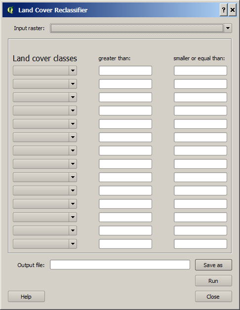
- Dialog box

Fig. 3.36 The dialog for the Land Cover Reclassifier
- Dialog sections
upper
Select raster land cover dataset to be reclassified into the UMEP land cover classes
middle
- Choose interval values to be classified into a certain UMEP land cover class.
Not all lines and boxes need to be filled in, but multiple lines are available in case many different intervals are to be classified as the same land cover class.
lower
Specify the output file (.tiff) etc.
- Input raster
Any valid raster dataset (float or integer) loaded into QGIS will appear in this dropdown list. Choose the one that includes your land cover information.
- Land cover classes
Fill the interval values that you want to reclassify into a certain cover class. All values not included will appear as 0 in the output land cover raster. This should be avoided.
- Output file
Location and filename (geoTIFF) are specified here.
- Run
Starts the reclassification.
- Close
Closes the plugin.