Note
Need help? Please let us know in the UMEP Community.
3.14. Urban Heat Island: UWG Prepare
Note
This plugin is still experimental. Please report any issues to our code repository.
- Contributor:
Name
Institution
Fredrik Lindberg
Gothenburg
Oskar Bäcklin
Gothenburg
- Introduction:
The Urban Weather Generator (UWG) tool is an implementation of the Ladybug application with the same name. The original Urban Weather Generator was developed by Bruno Bueno for his PhD thesis at MIT. Since this time, it has been validated 3 times and has been enhanced by Aiko Nakano. In 2016, Joseph Yang also improved the engine and added a range of building templates. For more detailed information on UWG, follow the links above.
The pre-processor UWG Prepare can be used to prepare input data for the UWG in UMEP or elsewhere. THis plugin generateds a uwg-file for each area that should modelled. An example of such a file can be found here This plugin make use of other UMEP pre-processors that is used to gather spatial information required.
- Related Preprocessors, Processors and Postprocessors
Urban Heat Island: UWG Reclassifier, Urban Land Cover: Land Cover Fraction (Grid), Urban Morphology: Morphometric Calculator (Grid), Urban Heat Island: Urban Weather Generator, Urban Heat Island: UWG Analyser
- Dialog box:
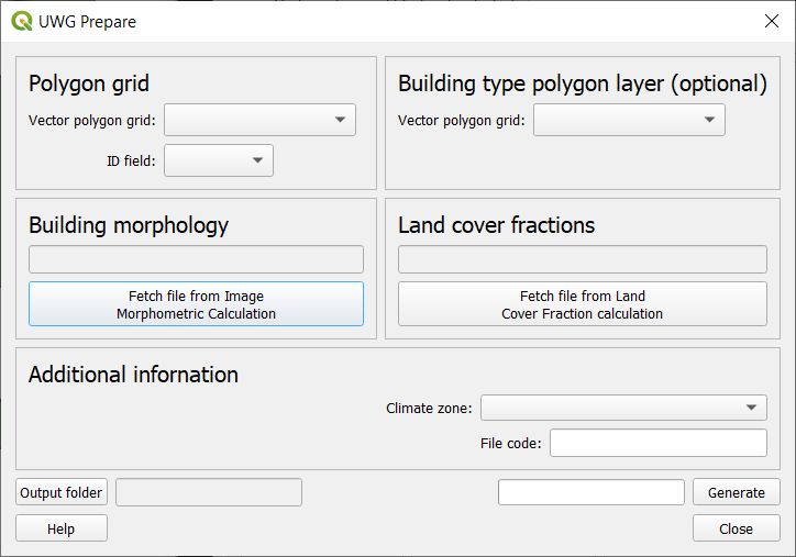
Fig. 3.31 Dialog for the UWG Prepare plugin. Click on image for enlargement.
Parameters:
Polygon grid
A vectory polygon grid that depicts the modelling area(s). This should be the same polygon layer that was used in Urban Heat Island: Urban Weather Generator. The ID field should an attribute field with unique numbers, preferably intergers.
Building type polygon layer
The vector polygon layer generated by Urban Heat Island: UWG Reclassifier. This is optional. If not used, all bildings are classified as mid-rise residential apartments.
Building morphology
Specify a text file on building morphology that are generated with the Image Morphometric Calculator plugin. Use the isotropic text file (*prefix*_IMPGrid_isotropic.txt).
Land cover fractions
Specify a text file on land cover fractions generated with the Land Cover Fraction plugin. Use the isotropic text file (*prefix*_LCFG_isotropic.txt).
Additional information
Here a climate zone should be specified as well as an prefix that will be used in the UWG and UWGAnalyser later on.
- Ourput folder:
Directory where generated files will be stored.
- Generate:
Starts the process.
- Help
Link to this manual page.
- Close:
Closes the plugin.
- Remarks
The building type polygon layer does not need to be fully covered. Fractions within a grid is calculated based on the area of various building type polygons. If no polygons are located within a grid, mid-rise apartments will be used.