Note
Need help? Please let us know in the UMEP Community.
4.11. Urban Wind Fields: URock
- Contributor:
Name
Institution
Jérémy Bernard
Gothenburg
Fredrik Lindberg
Gothenburg
Sandro Oswald
Vienna (ZAMG)
- Introduction
The URock plugin can be used to calculate spatial variations of wind speed and wind direction in 3 dimensions using 2.5D building and vegetation data. The methodology originates from Röckle (1990) and has been previously implemented in proprietary softwares such as QUIC-URB (Brown et al., 2013) or SkyHelios (Fröhlich and Matzarakis, 2018). The URock model, based on the H2GIS database and Python libraries is further described in Bernard et al., 2023. The current version of the model is 2023a.
This tools requires Java. If Java is not installed on your system, visit for example www.java.com and install the latest version. Make sure to install correct version based on your system architecture (32- or 64-bit). You can also download and install an open source packaged version of openjdk from https://adoptium.net/ or vist https://openjdk.org/ to install manually.
- Dialog box
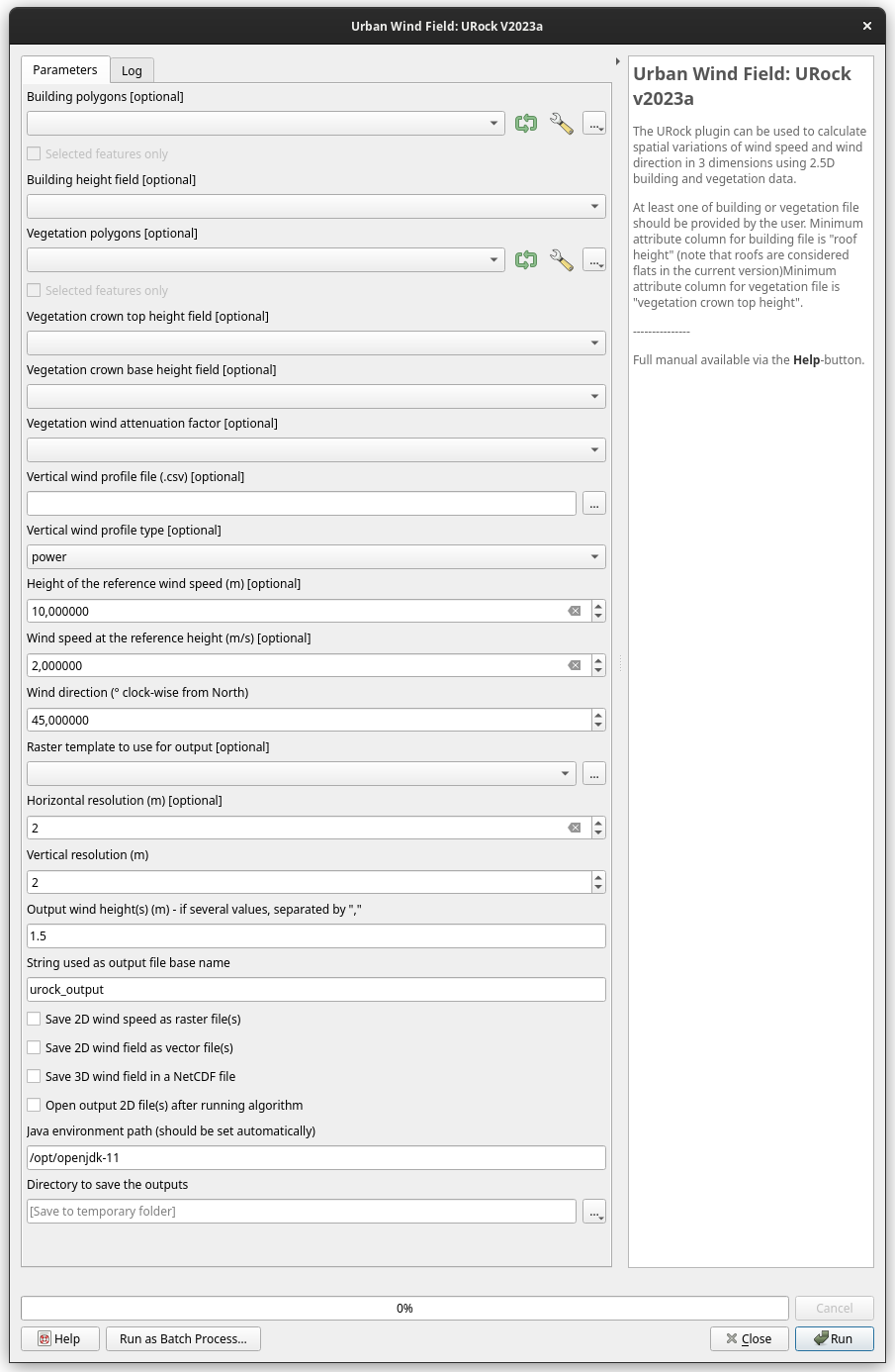
Fig. 4.15 The processing dialog for the URock model. Click on image for enlargement.
- Input parameters
Building polygons
Spatial input data containing buildings as 2.5D vector data
Building height field
Name of the attribute used to store building height (considered as flat roof)
Vegetation polygons (optional)
Spatial input data containing buildings as 2.5D vector data
Vegetation crown top height (optional)
Name of the attribute used to store the height of the top of the vegetation crown
Vegetation crown base height (optional)
Name of the attribute used to store the height of the bottom of the vegetation crown (the default is set to 25% of the crown top height)
Vegetation wind attenuation factor (optional)
Name of the attribute used to store the vegetation factor attenuation (the default is set to 1.00 - Larch plantation - for more values refer to Cionco et al. (1978))
Vertical wind profile file (.csv) (optional)
Text file containing the vertical wind profile. It consists in two columns and no header: 1st column contain measurement height (m), 2nd column the corresponding wind speed (m/s)
Vertical wind profile type (optional)
If the wind profile file is not provided, need to set a vertical wind profile type and a reference wind height and speed (default ‘power’ law)
Height of the reference wind speed (m) (optional)
If the wind profile file is not provided, need to set a vertical wind profile type and a reference wind height and speed (default 10 m)
Wind speed at the reference height (m) (optional)
If the wind profile file is not provided, need to set a vertical wind profile type and a reference wind height and speed (default 2 m/s)
Wind direction (° clock-wise from North)
Main wind direction within the urban canopy (default 45°)
Raster to use as output (optional)
Limit the URock calculation to the raster extend and interpolated output to the raster grid
Horizontal resolution (m) (optional)
Grid resolution used along horizontal axes (default 2 m). If you want the raster resolution to be used, leave this cell blank.
Vertical resolution (m)
Grid resolution used along the vertical axis (default 2 m)
Output wind height (m) - if several values, separated by ‘,’
The horizontal variation of wind speed and wind direction can be saved for a given height / list of height (default only 1.5 m)
String used as output base name
Name of the output file without extension (default urock_output)
Save 2D wind speed as raster file(s)
For each height specified in ‘Output wind height’, the horizontal variation of the wind speed is saved in a raster file
Save 2D wind field as vector file(s)
For each height specified in ‘Output wind height’, a vector file is saved. It contains four fields: ‘HWS’ the horizontal wind speed (m/s), ‘WS’ the absolute wind speed (m/s), ‘VWS’ the vertical wind speed (m/s) and ‘HWD’ the horizontal wind direction (° from North clock-wise)
Save 2D wind speed in a NetCDF file
Save the URock output in a NetCDF file split into two groups containing: (i) 3D wind field for the whole domain, (ii) the vertical wind speed profile used as input
Java environment path (should be set automastically)
Java is used for some calculation and Python needs to know what is the Java environment path on your computer (a default value should be identified automatically)
Directory to save the outputs
A folder path where will be saved the output files
- Quick example on how to run URock
Download the (Göteborg test dataset).
Add the raster layers (DEM, DSM, and CDSM) and the building vector (buildings.shp) from the Goteborg folder into a new QGIS session. The coordinate system of the rasters is Sweref99 1200 (EPSG:3007). Please verify that it is the case. If not, save it with this coordinate system.
In order to run URock, some additional datasets must be created based on the raster grids and vector layer you just added. Open the ‘URock Prepare’ module from the UMEP Pre-processor and create building and / or vegetation vectors using DEM, DSM and buildings vector for buildings and CDSM for vegetation. Leave all other settings as default. Two layers should be created at the end of this preprocess: ‘Building with height’ and ‘Vegetation with height’.
Now you are ready to generate your first wind maps. Open URock and use the settings as shown in the figure below but replace the paths to fit your computer environment (Java environment path should be set automatically, do not modify this one). When you are finished, press Run.
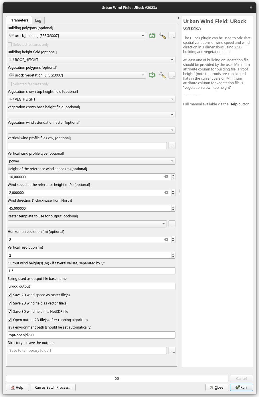
Fig. 4.16 Setting for a first try with the URock model. Click on image for enlargement.
- Remarks
This plugin is computationally intensive i.e. large grids will take a lot of time and very large grids (more than 30’000’000 3D grid cells) will not be possible to use.
URock consider building roofs as flat, thus do not trust wind speed near roofs if your building roof is normally not flat.
- References
Bernard, J., Lindberg, F., and Oswald, S.: URock 2023a: an open-source GIS-based wind model for complex urban settings, Geosci. Model Dev., 16, 5703–5727, https://doi.org/10.5194/gmd-16-5703-2023, 2023.
Brown, Michael J., Akshay A. Gowardhan, Mathew A. Nelson, Michael D. Williams, et Eric R. Pardyjak. « QUIC transport and dispersion modelling of two releases from the Joint Urban 2003 field experiment ». International Journal of Environment and Pollution 52, nᵒ 3‑4 (1 janvier 2013): 263‑87. https://doi.org/10.1504/IJEP.2013.058458.
Fröhlich, Dominik, et Andreas Matzarakis. « Spatial Estimation of Thermal Indices in Urban Areas—Basics of the SkyHelios Model ». Atmosphere 9, nᵒ 6 (juin 2018): 209. https://doi.org/10.3390/atmos9060209.
Rockle, R. “Bestimmung der Stomungsverhaltnisse im Bereich komplexer Bebauungsstrukturen der Technischen Hochschule Darmstadt Germany.” (1990).