Note
Need help? Please let us know in the UMEP Community.
1. Introduction
UMEP is a community open source model that users can contribute to improve and extend the modelling capabilities. It is free to download. A major feature is the ability for a user to interact with spatial information to determine model parameters. The spatial data across a range of scales and sources are accessed through QGIS - a cross-platform, free, open source desktop geographic information systems (GIS) application – that provides data viewing, editing, and analysis capabilities.
This software is in continuous development. There are two types of releases:
Long term release - this may be obtained from the QGIS plugin manager (see details).
Current development version - this can be obtained from the plugin repository. This version you need to manually install yourself (see details).
As of Spring 2020, most tools have been moved to UMEP for processing. This makes it easier to incorporate into prcesses within the QGIS eco-system. Find more info here. As of Spring 2026, versions of both UMEP and UMEP for processing compatible with QGIS4 is available as development release.
The UMEP plugin consist of three parts; a pre-processor, a processor and a post-processor. The pre-processor prepares spatial and meteorological data as inputs to the modelling system. The processor includes all the main models for the main calculations. To provide initial “quick looks” the post-processor will enable results to be plotted, statistics calculated etc. based on the model output. For more information on the content and archetecture, see Plugin Architecture.
Note
One essential part when working with geodata in a GIS is to make sure that a common coordinate reference system (CRS) is used, both for the data itself and the current QGIS-project you are working in. For more info, see here. It is strongly recommended to reproject/transform all geodatasets into the same projected coordinate system before any processing starts as well using a CRS that is based on meters.
1.1. UMEP: How to Cite
Please use the reference below when UMEP is used:
Lindberg F, Grimmond CSB, Gabey A, Huang B, Kent CW, Sun T, Theeuwes N, Järvi L, Ward H, Capel- Timms I, Chang YY, Jonsson P, Krave N, Liu D, Meyer D, Olofson F, Tan JG, Wästberg D, Xue L, Zhang Z (2018) Urban Multi-scale Environmental Predictor (UMEP) - An integrated tool for city-based climate services. Environmental Modelling and Software.99, 70-87 https://doi.org/10.1016/j.envsoft.2017.09.020
The manual should be cited as:
Lindberg F, Grimmond CSB, J Bernard, A Gabey, L Jarvi, CW Kent, N Krave, T Sun, N Wallenberg, HC Ward (2019) Urban Multi-scale Environmental Predictor (UMEP) Manual. https://umep-docs.readthedocs.io/ University of Reading UK, University of Gothenburg Sweden, SIMS China
1.2. License
UMEP and UMEP for Processing make use of GNU GPL3 license.
1.3. YouTube channel
Outdated but still relevant as general concepts are the same.
For a detailed description including how to install QGIS and UMEP for Windows, watch instruction video 1 and 2 on our YouTube-channel where you also can find other instructional videos related to UMEP and QGIS.
1.4. Plugin Architecture
1.4.1. Pre-Processor
P and M indicates is the plugin is avialable in UMEP for processing and/or UMEP from the menubar in QGIS, respectively.
Meteorological Data
Transforms meteorological data into UMEP format. (M) |
|
Prepare meteorological dataset from WATCH (deprecated). |
|
Prepare meteorological dataset from the Coopernicus programme. (P) |
Spatial Data
Plugin for retrieving geodata from online services suitable for various UMEP related tools (deprecated, see FAQ (Frequently Asked Questions) on how to retrieve data such population density). |
|
Creation/manipulation of a DSM based on user-specified building footprint vector data and/or Open Street Map data (if available) (P). |
|
Creation/manipulation of vegetation input data. (P) |
|
Conversion from Local Climate Zones (LCZs) in the WUDAPT database into SUEWS input data. (M) |
Urban geometry
Calculation of continuous maps of Sky View Factors (SVF) based on high resolution digital surface models (DSM). Solar access, urban heat island (P) |
|
Calculation of height and aspect of building walls based on a DSM. (P) |
Urban land cover
Reclassifies a grid into UMEP format land cover grid. Land surface models (M) |
|
Land cover fractions estimates from a land cover grid based on a specific point in space. (P) |
|
Land cover fractions estimates from a land cover grid based on a polygon grid (P) |
Urban Morphology
Morphometric parameters from a DSM based on a specific point in space. (P) |
|
Morphometric parameters estimated from a DSM based on a polygon grid. (P) |
|
Source area calculated from a DSM based on a specific point in space. Interpretation of observations (M) |
Urban Energy Balance
A plugin to easier introduce new, and investigate old parameters for the SUEWS model using an urban typology database (M) |
|
Preprocessing and preparing input data for the SUEWS model using an urban typology database (P) |
|
Preprocessing and preparing input data for the SUEWS model (M) |
|
Tool for converting input forcing data from older versions of SUEWS (M) |
Urban Heat Island
Preprocessing and preparing input data for the TARGET-model. (P) |
|
Preprocessing and preparing input data for the Urban Weather Generator (UWG). (M) |
|
Tool to reclassify urban topologies into UWG building classes. (M) |
Urban Wind fields
Tool to prepare spatial input data for the URock model. (P) |
1.4.2. Processor
Outdoor Thermal Comfort
Spatial variations of Tmrt in complex urban environments. Human Health: Outdoor thermal comfort; Park planning; Heat/Health warning; Daily Operations: visitors to parks (PM) |
|
Identify heat waves and cold waves for a certain location. Human Health: Outdoor thermal comfort; Daily City Operations: Energy use; Gas consumption (M) |
|
Identify locations for new trees based on mitigation of high radiant loads (heat stress). Human Health: Outdoor thermal comfort; Park planning; Heat/Health warning; Urban vegations; Street trees (P) |
Urban Energy Balance
Spatial variations anthropogenic heat release for urban areas (M) |
|
Anthropogenic Heat (QF). Daily City Operations: Energy use; Gas consumption; Traffic heat loads (M) |
|
Urban Energy and Water Balance. Disaster Risk Management: Drought, Heat; Environment evaluation for construction, Water Management, Green infrastructure (M) |
|
Urban Energy and Water Balance. Disaster Risk Management: Drought, Heat; Environment evaluation for construction, Water Management, Green infrastructure (P) |
Solar Radiation
Solar irradiance on building roofs and walls in urban environments. Economy and planning: Energy production, resource planning (P) |
|
Shadow patterns on a DSM and CDSM. Economy and planning: Resource planning Human Health: Outdoor thermal comfort; Park planning (P) |
Urban Heat Island
Model to calculate nocturnal urban heat island. (P) |
|
Model to calculate intra-urban air temperature differences based on urban gepmetry and vegetation. (P) |
Urban Wind fields
Semi-empirical model to estimate 3D wind fields in urban settings. Model is based on (Röckle 1990) Thermal comfort; Urban outdoor planning; Wind loads. (P) |
1.4.3. Post-Processor
Solar Radiation
Plugin to visualse output irradiation from SEBE on building roofs, walls and ground. (M) |
Outdoor Thermal Comfort
Plugin for plotting, statistical analysis and post-processing of model results from SOLWEIG. (PM) |
|
Plugin to produce maps of thermal comfort indices using output from SOLWIEG and URock. (P) |
Urban Energy Balance
Plugin for plotting and statistical analysis of model results from SUEWS simple and SUEWS advanced. (PM) |
Urban Heat Island
Plugin for statistical spatial analysis of model results from UWG (PM) |
|
Plugin for statistical spatial analysis of model results from TARGET (PM) |
Benchmark
For statistical analysis of model results, such as SUEWS. (M) |
Urban Winds Fields
Plugin for analyzing and vizualising URock resluts (P) |
1.5. Tool Applications
A key element of UMEP is to facilitate the preparation of input data needed for City-Based Climate Services (CBCS). UMEP provides both guidance and tools that enable data preparation and manipulation. This is particularly important as many end-users have familiarity with some, but not the full spectrum, of the data needed for applications. Below you can find some examples on applications and workflows for the modelling procedure in UMEP and what tools that are connected to each other.
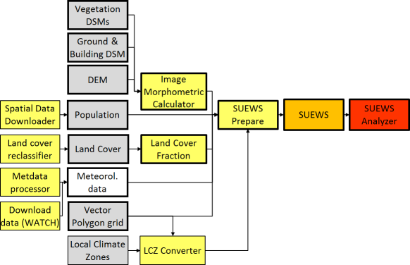
Fig. 1.1 Workflow and geodata used for analysing urban energy balance using the SUEWS model. Bold outlined boxes are mandatory items. Yellow, orange and red indicates pre-processor, processor and post-processor tools, respectively. Grey boxes indicate geodatasets.
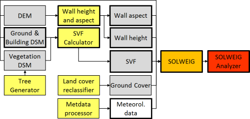
Fig. 1.2 Workflow and geodata used for analysing mean radiant temperature using the SOLWEIG model. Bold outlines are mandatory items. Yellow, orange and red indicates pre-processor, processor and post-processor tools, respectively. Grey boxes indicate geodatasets.
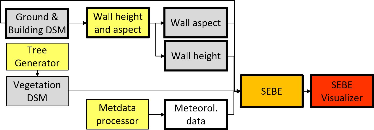
Fig. 1.3 Workflow and geodata used for analysing solar irradiance on building envelopes using the SEBE model. Bold outlines are mandatory items. Yellow, orange and red indicates pre-processor, processor and post-processor tools, respectively. Grey boxes indicate geodatasets.
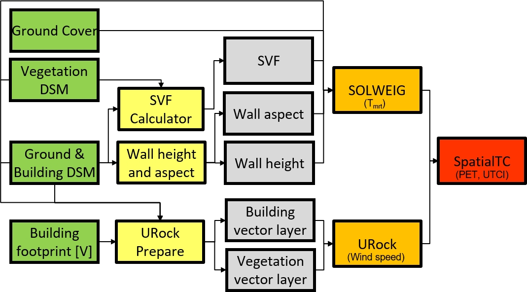
Fig. 1.4 Workflow and geodata used for analysing spatial variations of Thermal comfort indicies. Yellow, orange and red indicates pre-processor, processor and post-processor tools, respectively. Grey boxes indicate geodatasets.
1.5.1. Evaluation and application studies
The tables of studies below is by no means complete. Please help us adding studies by submitting an issue to this documentation repository found here.
- Mean Radiant Temperature (SOLWEIG)
References: Development
Action
Reference
Main model
Vegetation scheme
Cylindric shaped human
Ground cover scheme
Anisotrophic shortwave radiation scheme
GPU parallel computing
Anisotrophic longwave radiation scheme
GPU parallel computing
Wall surface temperature scheme
References: Evaluation
Spatial reference
Reference
Gothenburg, Sweden
Gothenburg, Sweden
Freiburg, Germany
Kassel, Germany
Freiburg, Germany
London, UK
Hong Kong, China
Shanghai, China
Szeged, Hungary
Phoenix, US
Salt Lake City, US
Gothenburg, Sweden
References: Application
Spatial reference
Reference
London, UK
Multiple cities, Sweden
Adelaide, Australia
Berlin, Germany
Multiple cities, Europe
Gothenburg, Sweden
Gothenburg, Sweden
Stockholm, Sweden
Santos, Brazil
Montreal, Canada
Vancouver, Canada
Seoul, South Korea
Bilbao, Spain
Gothenburg, Sweden
Nanjing, China
Freiburg, Germany
Phoenix, US
Gothenburg, Sweden
Hobart, Australia
Nanjing, China
Major cities, US
Philadelphia, US
Chengdu, China
Barcelona, Spain
Ghent, Belgium
Vancouver, Canada
Nicosia, Cyprus
- Pedestrian Wind Speed
References: Evaluation
Spatial reference
Reference
NA
NA
- Anthropogenic Heat (Qf) (LUCY)
References: Evaluation
Spatial reference
Reference
Global
References: Application
Spatial reference
Reference
Europe
- Solar Energy on Building Envelopes (SEBE)
References: Evaluation
Spatial reference
Reference
Gothenburg, Sweden
Bolzano, Italy
Vienna, Austria
São Paulo, Brazil and Raalte, the Netherlands
References: Application
Spatial reference
Reference
Dar es Salam, Tanzania
Stockholm, Sweden
Uppsala, Sweden
Gothenburg, Sweden
Eskilstuna, Sweden
Madrid, Spain
Trondheim, Norway
- Daily Shadow Patterns
References: Evaluation
Spatial reference
Reference
Borås, Sweden
Guangzhou, China
References: Application
Spatial reference
Reference
London, UK
Gothenburg, Sweden