Note
Need help? Please let us know in the UMEP Community.
3.7. Spatial Data: Tree Generator
Developer:
Name |
Institution |
Fredrik Lindberg |
Gothenburg |
- Introduction
Information 3d vegetation is not a common spatial information available. The Tree Generator can be used to create or alter a vegetation CDSM and TDSM (see abbreviations). By using information from a point layer where the location of the points specifies the tree positions and the attributes sets the shape of the trees, it is possible to produce a 3d vegetation rasters needed for e.g. Mean radiant temperature modelling (SOLWEIG) or Urban Energy Balance modelling (SUEWS) in UMEP.
- Dialog box
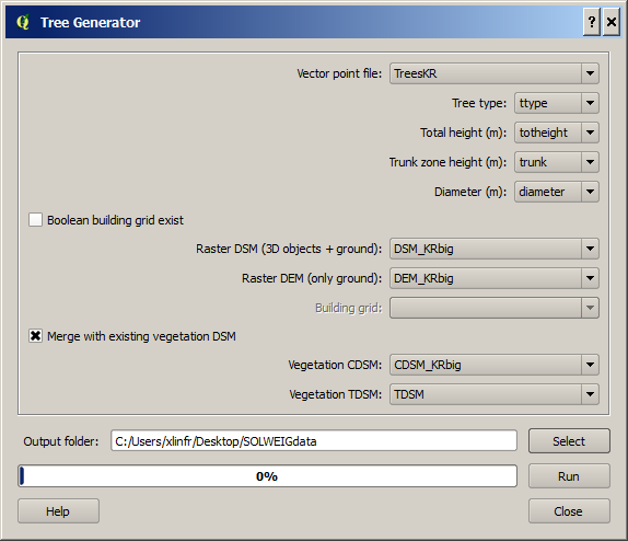
Fig. 3.11 The dialog for the Tree generator
- Dialog sections
top
input data is specified
bottom
to specify the output and to run the calculations
- Point vector file
A point vector file including the appropriate attributes for generating the vegetation DSMs
- Necessary attributes
Tree type
Two different tree types (shapes) are currently included: 1 = conifer, 2 = decidouos. There is also a possibility to remove vegetation by setting tree type = 0 and with an appropriate diameter to remove all vegetation pixels from the DSMs.
Total height
This is the total height of the tree from the ground (magl).
Trunk height
This is the height up to the bottom of the canopy (magl).
Diameter
This is the circular diameter of the tree in meter.
- Bollean building grid exist
Tick this in if a boolen building grid exist for your model domain. This can be generated from the SOLWEIG-plugin.
- Building and Ground DSM
A DSM consisting of ground and building heights.
- Ground DEM
A DEM cosisting of ground heights.
- Building grid
A grid where building pixels are 0 and all other pixels are 1.
- Vegetation Canopy DSM
A DSM consisting of pixels with vegetation heights above ground.
- Vegetation Trunk Zone DSM
A DSM (geoTIFF) consisting of pixels with vegetation trunk zone heights above ground.
- Output Folder
A specified folder where the result will be saved.
- Run
Starts the calculations
- Close
closes the plugin.
- Output:
Two geoTIFFs are created, one CDSM and one TDSM.
- Remarks:
All DSMs need to have the same extent and pixel
To ceate a bush, set trunk height to
The SOLWEIG plugin can be used to create the boolean building grid as well