Note
Need help? Please let us know in the UMEP Community.
3.6. Spatial Data: Spatial Data Downloader
Developer:
Name |
Institution |
Andy Gabey |
Reading |
Note
This plugin is depracated as from July 2020. Visit our YouTube Channel and watch the link on how to access Web Services using QGIS instead.
- Introduction
The Spatial Data Downloader downloads geo-datasets useful for UMEP applications. Only the necessary section of the data is downloaded, so that disk use and download time are minimised.
- Dialog box

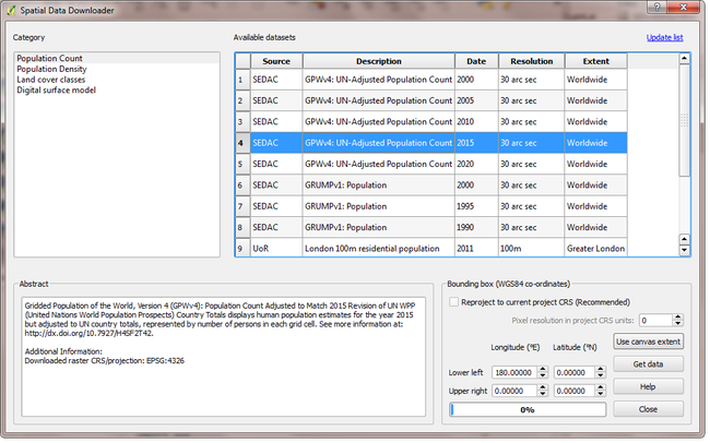
Fig. 3.10 Dialog for the Spatial Data Downloader plugin
- Category and available datasets
Each category contains multiple datasets, which are revealed by clicking the category name. To download a dataset, select it from the list, specify the geographic extent and press “Download”
- Abstract
Information about the selected dataset, including citation information.
- Bounding box
The geographic extent of the region to download (maximum download size is 500x500 pixels in the case of raster data). The current QGIS canvas extent can also be used by clicking Use canvas extent
- Reproject to current project CRS
The downloaded data is saved in its original CRS by default. This option reprojects the saved data to the project CRS and performs resampling, the resolution of which is controlled by the “Pixel resolution in CRS units” box.
- Get data
Refreshes the catalogue of available datasets. This is also updated when QGIS starts.
- Update list
Refreshes the catalogue of available datasets. This is also updated when QGIS starts.
- Close
Closes the plugin.